


Air Navigation Pro


Descriere Air Navigation Pro
Descoperiți gratuit aplicația noastră de planificare a zborului și navigare în timp real timp de 28 de zile!
- Tot ce ai nevoie pentru a zbura în jurul lumii
- Planificați-vă zborul în câteva minute
- Zburați relaxat cu informații actualizate
Air Navigation Pro este o aplicație de asistent de zbor de înaltă calitate pentru piloții din întreaga lume. Beneficiați de următoarele caracteristici principale:
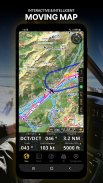
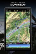
HARTĂ MUSCĂ
Planificați și navigați folosind harta noastră interactivă în mișcare. Alegeți între hărți aeronautice, satelit sau harta noastră vectorială ca fundal. În plus, harta în mișcare afișează puncte de referință, NOTAM, obstacole și spații aeriene din baza noastră de date aeronautică completă și mereu actualizată la nivel mondial. Atingeți orice punct de referință direct pe hartă pentru a crea cu ușurință o rută. Personalizați valorile afișate în bara de navigare pentru a avea exact informațiile de care aveți nevoie: altitudine, viteză verticală, direcție, distanță până la următorul punct de referință, calcule ETA etc. Alegeți procedurile de plecare și sosire din aeroport pentru ruta dvs. pentru a le avea și ele afișate în partea de sus a hărții în mișcare.
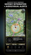
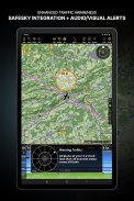
CONștientizare sporită privind traficul
Primiți alerte vizuale și audio în toate limbile pentru traficul conflictual din apropiere. Alegeți pictograma de trafic preferată între simbolurile generice, aeronave sau TCAS. Siguranța dvs. este importantă pentru noi, motiv pentru care am colaborat cu SafeSky pentru a ne asigura că utilizatorii noștri au date de trafic live în timpul zborului. Beneficiați de integrarea nativă cu SafeSky inclusă în noile noastre abonamente Smart Lite, Smart Classic și Smart Advanced — un pachet două în unu!
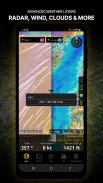
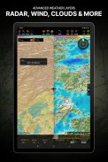
STRATURI METEO AVANSATE
În plus față de rapoartele meteorologice de bază ale vântului și TAF/METAR pentru zborul dvs., abonații planului Smart Advanced pot activa straturi meteorologice transparente deasupra hărții în mișcare. Straturile disponibile includ radar de ploaie, vânt, presiune, nori și ploaie, vizibilitate, rafală și, în plus, pentru Germania, Elveția, Austria și Balcani, relatează GAFOR. Atingeți orice punct de pe hartă pentru a vedea informațiile meteo pentru acea zonă. Consultați prognoza meteo pentru până la trei zile înainte.
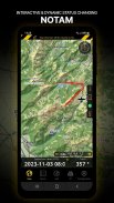
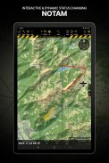
NOTAM
După crearea traseului, setați ora de plecare în viitor pentru ca harta în mișcare să afișeze NOTAM-ul activ pentru acea oră specifică. NOTAM-ul de pe hartă își schimbă culoarea în mod dinamic în funcție de starea lor.
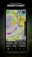
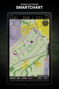
SMARTCHART
SmartChart nostru de ultimă oră este o hartă vectorială foarte detaliată și inteligentă, care se adaptează nevoilor dumneavoastră, oferindu-vă informații adecvate la orice nivel de zoom. SmartChart optimizează afișarea umbrelor pentru a distinge cu ușurință între văi și munți, iar textul rămâne perfect aliniat, garantând o lizibilitate optimă. Inclusiv cele mai recente îmbunătățiri semnificative cu păduri și informații detaliate despre aeroport.
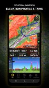
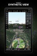
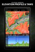
PROFIL DE ELEVAȚIE ȘI VEDERE SINTETICĂ
Activați vizualizarea profilului de sub bara de navigare pentru o conștientizare îmbunătățită a situației a cotei din fața dvs. sau de-a lungul traseului. Alegeți lățimea coridorului între 0 și 5 NM și opțiunile de suprapunere: spații aeriene, NOTAM, obstacole, componente ale vântului, locuri populate etc. Comutați la vizualizarea sintetică pentru informații suplimentare despre teren, plus un orizont artificial cu indicatori de altitudine și viteză verticală. Această funcție poate fi folosită și pentru a vă deplasa în timp ce vă pregătiți pentru zborul dumneavoastră. Activați TAWS pe harta în mișcare, precum și pe vizualizarea sintetică.
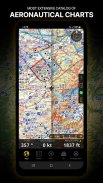
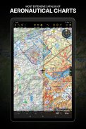
HARTE AERONAUTICE ȘI HARTE DE APROPIERE
Oferim cel mai extins catalog mondial de hărți aeronautice, inclusiv hărțile ICAO. Afișați diagramele de abordare georeferențiate deasupra hărții în mișcare sau a vizualizării sintetice.
BRIEFING
Pregătiți-vă zborul cu secțiunea noastră de informare creând documente cu NOTAM și hărți și stații meteo relevante pentru ruta planificată. Optimizați timpul creând un profil de aeronavă care va fi folosit în secțiunea Briefing pentru a completa pentru dvs. Planul de zbor ATC și pentru a calcula W&B.
SI MULTE MAI MULTE!
Un abonament vă permite să utilizați aplicația pe trei dispozitive. Vă recomandăm să creați un cont de navigație aeriană pentru o gestionare îmbunătățită a dispozitivelor. Consultați manualul nostru de utilizare de pe site-ul nostru web: www.airnavigation.aero pentru mai multe informații.
Air Navigation Pro - Versiune 8.4.5.505070725
(08-05-2025)

Air Navigation Pro - Informații APK
Versiune APK: 8.4.5.505070725Pachet: com.xample.airnavigationCea mai recentă versiune a Air Navigation Pro
Alte versiuni


Aplicații din aceeași categorie


S-ar putea să îți placă și...


